Mount Catherine Trailhead
Where can you find unobstructed views of Mount Rainier and the mountains of Snoqualmie Pass, see rare butterfly species, and go berry-picking, all in return for a modest 1330-foot elevation gain? Mount Catherine, of course! This off-the-beaten-path hike to the summit of a wintertime ski destination is one of the most rewarding climbs along the southern wall of Snoqualmie Pass.
The trailhead for Mount Catherine is reached via FR-9070, a gateway to some of the less-traveled and better-kept secrets of the Cascades. FR-9070 has its share of potholes and is usually snow-free from July until November. Park along the south side of FR-9070 across from a modest sign indicating trail #1348. There are no water sources on this hike, but the round trip is only three miles.
Mount Catherine packs in 1,330 feet of elevation gain over 1.5 miles, so be prepared for a hike that climbs aggressively with switchbacks as it ascends the mountain’s southern flank. Catch your breath and note the western and mountain hemlock cones that line the trail. Subalpine fir is another resident of this neighborhood, occupying the more wind-exposed turns of the trail. Blowdowns occasionally pose obstacles along this trail.
The first 0.7 miles of trail lift you up to the ridgeline at 4,700 feet of elevation, near the western side of the mountain. The trail then traces the ridgeline for 0.6 miles, heading east and climbing more gently. In the early summer this section of the trail may be partially covered by lingering snow. Over the last 0.2 miles, nearing the summit block, the trail turns north and views start to open. Mount Rainier looms over the horizon behind you. Circle around the summit block, turning east again, where you may encounter a snow bank in June and early July—cross carefully if there is snow, as there is nothing to stop your slide for more than 100 feet. Just beneath the summit, you may encounter a cable that can be used to assist in a brief scramble that gains the final 20 feet to the top. Alternatively, there are class 2-scramble bootpaths that reach the top.
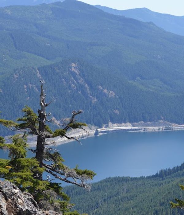
As you close in on the summit, huckleberry bushes line the trail. Berries tend to ripen in August and September. The rare and endangered Taylor’s checkerspot butterfly frequents this summit, too. When you reach the top, from left to right, Mount Rainier, Tinkham Peak, and Silver Peak dominate the view. To the east, in the distance, is Mount Stuart. North of you lie Chair Peak, Kaleetan Peak, Red Mountain, and Snoqualmie Mountain. To the northwest, if you squint, you can make out the fire lookout atop Granite Mountain. And to the southeast is glorious blue Keechelus Lake.
WTA Pro Tip: Since the round-trip distance for this hike is a relatively short, consider combining Mount Catherine with Tinkham Peak, Silver Peak, or Twin Lakes, as the trailheads for those hikes are also along FR-9070.
Other Recommendations Around Snoqualmie Pass


Red Mountain Coffee